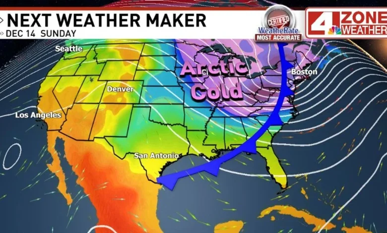
SAN ANTONIO – Big weather changes are ahead this weekend as an arctic cold front moves across Texas.
Before we talk about the upcoming weekend forecast, lets take a moment to look at Friday morning in our region. Dense fog could be an issue for the morning commute as milder, humid air along the Gulf coast pushes inland overnight. This time of the year when nights are cool to chilly, this can easily develop a layer of clouds and dense fog.
Friday morning fog risk (visibility in miles)
Visibility could hit a 1/4 mile or less with mist making roads slick too. Some pockets of fog could linger into the noon hour with improvement through the afternoon but clouds could linger keeping temperatures from reaching the 70s.
Now the weekend forecast. Saturday is the day to enjoy outdoors if you prefer warm temperatures. It may be a cloudy start to the day with sprinkles or a couple showers then turns partly sunny in the afternoon.
An arctic cold front will be cutting southeast across the country which puts Texas just outside the path of the coldest air. Temperatures could be in the single digits to below zero in the Midwest to Great Lakes. Given this is arctic air, even a glancing shot of it can have a big impact and we will see this Sunday.
The front arrives early Sunday with a 30% chance of sprinkles or light showers in the area. The rest of the day Sunday is cloudy, colder and windy.
Future clouds & radar Sunday early morning
Future clouds & radar Sunday early afternoon
Wind gusts Sunday 25 – 35mph
We’ll be on the outer edge of this air mass but temperatures may fall to the 40s to low 50s Sunday afternoon. This change is more dramatic after a warm humid day Saturday. We will need to closely watch trends Sunday night for freeze potential in our area. Most model guidance we lean on for forecasting is well above freezing but one hi-res computer model is coming in colder. One thing I’ve found in over 25yrs forecasting, computer models can have a hard time with arctic air masses.
Morning low temperatures ahead
Monday ends up being a cloudy day and chilly in the 50s. A cloudy day Tuesday prevents a big warm up along with the risk for a few late day showers into Tuesday night. Much warmer temperatures move back into the area later next week.
Big temperature swing ahead
Comment with Bubbles
BE THE FIRST TO COMMENT
To top things off, trends Christmas week continue to strongly lean warmer than normal in Texas.
8 – 14 day temperature outlook from Climate Prediction Center