Winds Wednesday evening in Philadelphia region could prompt power outages. Here’s the weather forecast.
Temperatures fall into the mid-30s to near 40 degrees by daybreak Wednesday in the Philadelphia region.
A little patchy frost may form in colder pockets of South Jersey and Delaware, but temperatures will warm quickly once the sun comes up and the south winds begin to usher in warmer air ahead of a cold front.
CBS News Philadelphia
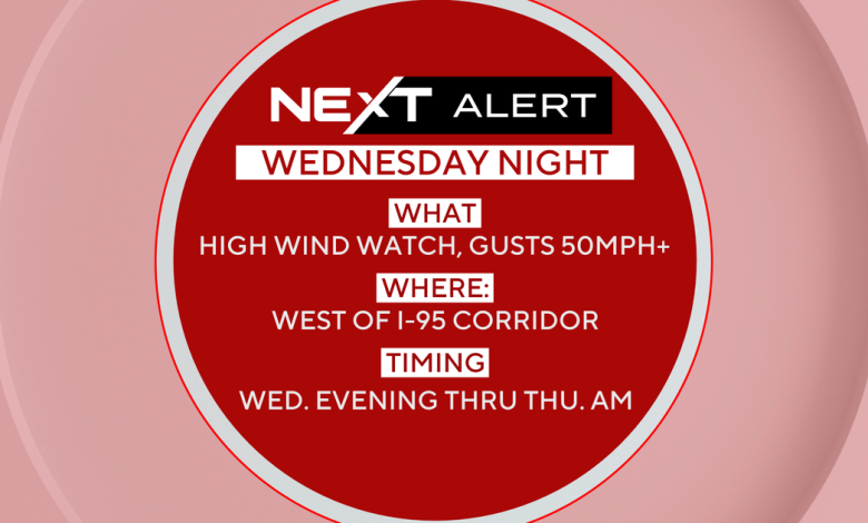
That front moves through Wednesday night, bringing a few showers, mainly north of Philadelphia. Winds turn gusty again behind the front before calming down Thursday as high pressure briefly returns. Due to the winds, a NEXT Weather Alert will be in effect for Wednesday night through Thursday morning.
Temperatures dip into the 40s and 50s Thursday before warming back into the 60s Friday.
A stronger system approaches Friday night with rain and gusty winds, marking the start of a more unsettled weekend pattern with the greatest chance of rain coming in on Sunday.
CBS News Philadelphia
Next week will be cold. Highs Monday and Tuesday will only stay in the mid-upper 40s with widespread freezing temps likely by Tuesday morning.
Here’s your 7-day forecast:
CBS News Philadelphia
Wednesday: Windy, a few p.m. showers. High 68, Low 40.
Thursday: Cooler. High 58, Low 48.
Friday: A late shower. High 62, Low 39.
Saturday: Mixed skies. High 68, Low 56.
Sunday: Afternoon/evening showers. High 63, Low 49.
Monday: The big chill. High 48, Low 40.
Tuesday: Sunny and frosty. High 47, Low 33.
NEXT Weather Radars
Hourly Forecast