- Chilly daytime highs
- Gusty winds
- Accumulating snow for some Monday
FAWD
In light of some bitter cold, we’ve issued First Alert Weather Days for the entirety of your Monday, plus Tuesday morning.
A First Alert Weather Day has been issued for Monday into Tuesday morning for the cold.(WDBJ)
Monday
Yesterday’s cold front brought some major changes to the forecast. For starters, you’re really going to notice a change in those temperatures. The majority of us are starting the morning off in the 30s, and these strong gusty winds are resulting in wind chills that toe the line with freezing.
Temperatures and wild chills today are resulting in some bitter cold(WDBJ7)
Chilly Tuesday
Tonight into Tuesday morning will feature the coldest of conditions of the week. Overnight lows will be falling into the 20s and teens for most of the region. Factor in a 10-20 mph sustained wind, and feels-like temperatures will be down into the teens and single digits across the area.
The coldest of conditions will come Monday night.(WDBJ)With air temperatures in the teens/20s, feels-like temperatures will be even colder Tuesday morning.(WDBJ)
Tuesday won’t be much better in regards to warmth, as highs will struggle to make it into the 40s yet again.
Highs will struggle to climb into the 40s Monday and Tuesday.(WDBJ)
Wintry Weather for Some
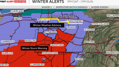
Areas that have potential to see any snow have been placed under a winter weather advisory in effect until 7 AM Tuesday. Impacted areas might see some slick conditions on the road, so be sure to drive with caution!
Winter Weather Advisories and Winter Storm Warnings are in place for a few counties(WDBJ7)
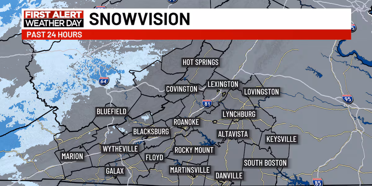
Snow showers are looking to stay localized toward some of the ski resorts in West Virginia. These snow showers will continue for our far western counties all throughout the day Monday, which could lead to some minor accumulation.
Accumulation of snow has stayed to the west of our coverage area in the WV mountains(WDBJ7)
Thanks to those strong NW winds Monday, a few snow showers could very well creep their way into the New River Valley; a few flakes could even creep close toward the Roanoke Valley. However, any falling snow in these areas will likely melt on contact with the ground. Therefore, little to no accumulation is expected in these areas.
Snow showers will continue toward the WV communities throughout the day Monday.(WDBJ)Most snow accumulations will reside toward West Virginia.(WDBJ)
Eventually Warming Back Up
In case you’re not a fan of the cold, there is some light at the end of the tunnel. Thanks to a more southwesterly/westerly down sloping wind entering the area, temperatures Wednesday through Friday will warm closer to normal for this time of year.
Highs will rebound closer to normal starting Wednesday.(WDBJ)
Copyright 2025 WDBJ. All rights reserved.