Pittsburgh braces for impactful snow and below-zero wind chills this weekend | First Alert Weather
It’s a quiet start to our Saturday before widespread, impactful snow moves across the region with an Alberta Clipper system.
WEATHER LINKS:
Current Conditions | School Closings & Delays | Submit Your Weather Photos
KDKA Weather Center
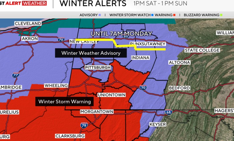
Winter Weather Advisories and Winter Storm Warnings start at 1 p.m. today and go until 1 p.m. Sunday. Areas north of I-80 are under a Winter Weather Advisory until 8 a.m. Monday with lake effect snow showers expected Sunday into early Monday behind the system.
Areas south of I-70 (Washington, Westmoreland, Greene, and Fayette County) are expected to see the highest amounts, about 6″ and 10″ for higher elevations, whereas areas in Allegheny and north will still get heavy snow but closer to the 3-5″ range.
KDKA Weather Center
Snow tapers off around midnight and becomes scattered through overnight and early tomorrow. Cold air follows behind, leaving us with lows in the single digits and wind chills below zero with gusts around 15-20mph.
KDKA Weather Center
Our highs on Sunday will only be in the low 20s and feeling in the single digits and teens all day, so bundle up if the kids are going to be outside playing.
KDKA Weather Center
Monday will also be a cold one with lows in the teens and highs in the low 20s with cloudy skies.
The rest of the week, we are seeing seasonable temperatures return to the low 40s on Wednesday. Rain arrives on Thursday with highs back in the low 50s before we are back to highs in the 30s on Friday.
Right now, it’s not looking like a white Christmas with above-normal temperatures returning around Christmas.
Stay up to date with the KDKA Mobile App – which you can download here!