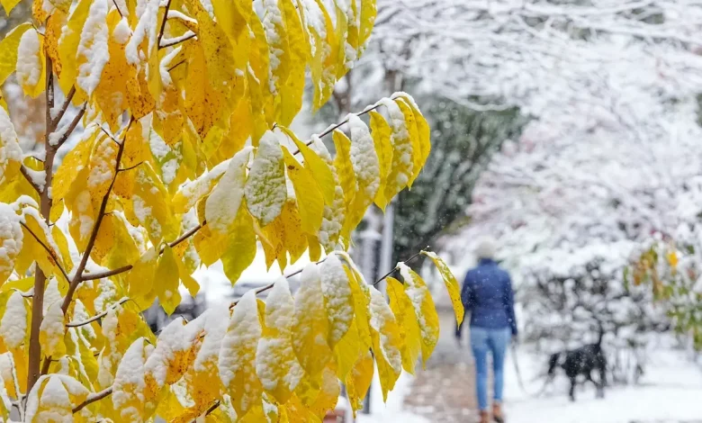
Lake-effect snow blankets states around the Great Lakes
Winter has arrived to states around the Great Lakes, with lake-effect snow blanketing streets from New York to Wisconsin.
- A potential wobble in the polar vortex could bring a return of arctic air to Ohio and the northern U.S. around Thanksgiving.
- Forecasts show below-average temperatures for about half the country through the end of November.
- A weakened polar vortex, influenced by other atmospheric patterns, increases the chance of cold outbreaks.
- The possibility of cold air moving over the Great Lakes raises the potential for lake-effect snow events.
Ohio could see a return of arctic air around Thanksgiving as models suggest a possible wobble in the polar vortex, which could push frigid air into the northern U.S.
It’s unclear whether this event will be as intense as this week’s system — which brought up to a foot of snow near Buffalo — though the cold is unlikely to reach as far south as it did when record-breaking low temperatures hit parts of Florida.
Forecasts from the Climate Prediction Center, which had previously projected above-normal temperatures for much of the U.S. this winter, now show below-average temperatures for roughly half the country through the end of November.
For Ohio and the Great Lakes, the potential for more lake-effect snow is already in the forecast.
“Slightly enhanced chances for above-median precipitation across the Great Lakes region is partly tied to possible lake effect snow events,” the Climate Prediction Center wrote on Nov. 7 about the last week of November.
Meanwhile, the Southeast and southern Great Plains are expected to remain warmer than normal.
What is the polar vortex? How does it impact Ohio winters?
The polar vortex is a swirling mass of frigid air high in the atmosphere that normally circles the arctic, according to the National Weather Service. Sitting in the stratosphere, it usually keeps the coldest air locked near the North Pole.
Contrary to what its description may suggest, a weakened polar vortex can bring harsher winter weather to Ohio and the rest of the U.S., while a strong vortex keeps arctic air contained, leading to milder winter conditions here.
What does the polar vortex look like right now?
Right now, charts show the polar vortex is unusually weak — similar to its strength in early autumn — and could wobble south, sending Arctic air into the U.S. around Thanksgiving.
This weakness is linked to very low winds high above the Arctic, called zonal winds, which are now declining and approaching 0 m/s, a threshold that can trigger an event called major sudden stratospheric warming (SSW). These events often lead to significant cold outbreaks and even blizzards.
(Note about graph: The dashed 0 m/s line marks the boundary between westerly winds (above the line), which represent a normal, intact stratospheric polar vortex, and easterly winds (below the line), which indicate a reversal of the vortex and meet the definition of a major sudden stratospheric warming if sustained. In the graph, many forecast members (blue lines) dip toward or below 0 m/s in late November, showing the potential for a significant weakening or even reversal of the 10 hPa zonal winds, compared with the typical climatological values shown in red.)
The vortex’s instability is also influenced by the Quasi-Biennial Oscillation (QBO), a stratospheric wind pattern that shifts between easterly and westerly roughly every 28–29 months. When the QBO is in its easterly phase, as it is now, the vortex is more prone to wobble south.
Meanwhile, a weak La Niña in the lower atmosphere is shaping winter patterns as well. While it doesn’t directly affect the polar vortex, it can shift the jet stream, influencing where arctic air travels and how long cold outbreaks linger. La Niña may also leave parts of the Great Lakes unfrozen, increasing the risk of lake-effect snow when colder arctic air moves over warmer open water.
Ohio weather forecast for Thanksgiving
From Nov. 22 to Dec. 5, forecasters expect temperatures to swing between warmer and colder periods across the U.S.
Just ahead of the holiday, the West may run cooler than average, while the East — including Ohio — could stay slightly above normal. But by Thanksgiving, Arctic air could drop south across the northern U.S., raising the odds of below-normal temperatures in Ohio and the Great Lakes.
The Climate Prediction Center says larger-scale drivers — including the Madden-Julian Oscillation, a tropical thunderstorm pattern, and La Niña, a cooling of the tropical Pacific — can help steer cold air into the U.S. around Thanksgiving. Together, they point to an “increased cold air intrusion across the northern tier of the contiguous United States” during that period.
This could mean more lake-effect snow is on the horizon for those in the Great Lakes.
Local forecasts from the National Weather Service in Wilmington, Ohio signal a similar setup, according to the area forecast discussion.
Forecasters say the jet stream may flatten by midweek — a pattern called “quasi-zonal flow” — allowing several small disturbances to pass through. These shortwaves may bring periods of rain and, if temperatures dip enough, brief chances for snow.
Beyond that, confidence drops as the polar vortex weakens, although models generally suggest a more active and wetter pattern at the end of November into early December.
What is lake-effect snow?
Lake-effect snow typically happens when cold, dry Arctic air moves over a large, relatively warm lake, creating narrow bands of clouds that can dump snow anywhere from a few minutes to several days.
Wind direction also matters a lot — it can mean heavy snow in one town while a sunny mile or two away sees nothing:
- Westerly winds: These are common across northern Ohio. When cold air moves from the west over Lake Erie, it picks up moisture and warmth from the lake. As the air reaches land, that moisture condenses and falls as snow, often in narrow, heavy bands.
- Northwesterly winds: These can boost snowfall across northeast Ohio, including areas along the southern and eastern Lake Erie shoreline.
Ohio weather watches and warnings
Stay informed. Get weather alerts via text
Brandi D. Addison covers weather across the United States as the Weather Connect Reporter for the USA TODAY Network. She can be reached at baddison@gannett.com. Find her on Facebook here.