The country’s disaster chief is urging everyone in the Top End to act quickly as Tropical Cyclone Fina intensifies to a category 2 system and moves closer to the coast.
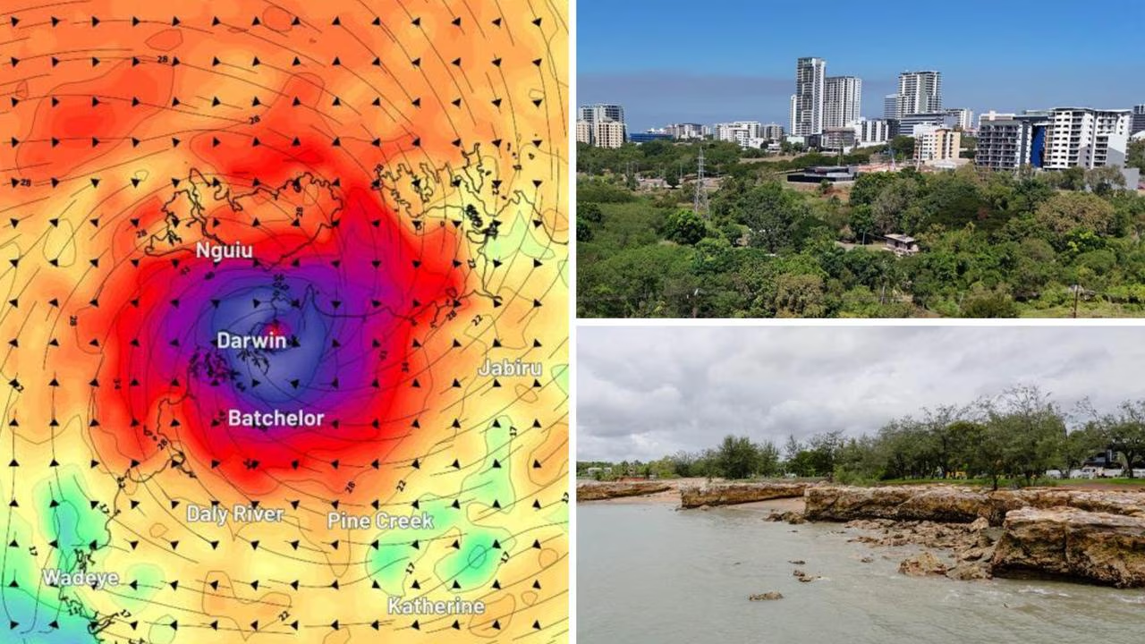
The cyclone is currently located about 60km north of Minjilang and 270 km northeast of Darwin, moving slowly southwest toward the Cobourg Peninsula and Tiwi Islands.
Residents in affected areas are being urged to take action immediately by securing their property, following their household emergency plans, and staying updated with official warnings to protect themselves and their families.
Federal Emergency Management Minister Kristy McBain warned on Friday that TC Fina could move “towards Darwin on Saturday night” and said she had been touch with the Northern Territory’s chief minister.
“NEMA has already deployed officials into the area,” she told reporters in the National Situation Room in Canberra.
“We have implemented our National Coordination Mechanism and we are arranging a range of strategic planning issues.
“We remain ready to assist if there are any requests for assistance.”
She said authorities would remain eagle-eyed but asked anyone in the region to their part too.
“It is really important now for community to listen to those emergency warnings from Secure NT, their emergency radio broadcasting channels, and we are asking community members to look out for vulnerable community members as well,” Ms McBain said.
“It is really important that we heed the advice of our emergency authorities right now.”
She also said generators had been pre-deployed.
Cyclone warning for Darwin and surrounding regions
Residents on the Tiwi Islands and across the Top End from Daly River Mouth to Warruwi, including Darwin, the Cobourg Peninsula, Minjilang, Gunbalanya, Pirlangimpi, Milikapiti and Wurrumiyanga, are now under a Watch and Act alert from NT Emergency Service.
“There is a heightened level of threat. Conditions are changing and you need to start taking action now to protect you and your family,” NTES said.
Risks include destructive winds, torrential rain, dangerous flooding, storm tides, and possible disruption to essential services such as electricity, water and gas.
NTES has urged residents to enact their household emergency plans, secure property, monitor conditions via Secure NT and the Bureau of Meteorology, and take extra care on the roads.
Gales with damaging wind gusts to 120 km/h are occurring over the Cobourg Peninsula and are expected to extend to the Tiwi Islands during Friday, with Darwin likely to experience gales from Saturday morning.
Heavy to locally intense rainfall could trigger flash flooding along coastal areas between the Tiwi Islands and Warruwi from Friday, spreading across the western Top End including Darwin over the weekend.
Coastal residents are also warned of a dangerous storm tide.
“(TC Fina) is likely re-intensifying and restrengthening,” a Bureau of Meteorology statement read.
Residents in the small town of Minjilang were earlier told to urgently seek shelter as the extreme conditions hit parts of Croker Island, about 235km east of Darwin.
The urgent warning was issued about 5.20am local time on Friday after destructive winds, torrential rain and flooding hit the area.
“You may be in danger and need to take action immediately,” the warning reads.
“Any delay now puts your life at risk.”
Cyclone forecast to develop into category 3 by weekend
While Fina weakened overnight, it has now re-intensified to a category 2 system and is expected to continue strengthening, potentially reaching severe tropical cyclone intensity (category 3) during overnight Sunday or early Monday as it moves through the southern Timor Sea.
There is a chance it could reach category 3 earlier, late Friday or early Saturday, as it moves into the Van Diemen Gulf.
“As a category 2 tropical cyclone, this would bring significant wind and rain impacts to those northern areas,” senior meteorologist Angus Hines said.
Cyclone carves slow path towards Darwin
While TC Fina is currently moving slowly towards the Tiwi Islands, meteorologists forecast its intensity could ramp up during the day, pushing it closer to land.
“There continues to remain a chance that it could reach category 3 intensity earlier, during late Friday or early Saturday as it moves into the Van Diemen Gulf,” the bureau website says.
The bureau warned the intensity of the cyclone could severely increase into Sunday as it moves over southern Timor Sea.
Mr Hines said damaging winds are forecast to hit between Cape Hotham and Warruwi, spanning the Coburg Peninsula, Minjalang and Gumballanya.
“We do expect those damaging winds to start in the next 24 hours, mostly through the second half of the day on Friday or into the early hours of the night into Saturday morning,” he said.
“Damaging winds will extend through those areas and could cause significant disruption, power outages, possible damage to property and trees as well. Rain will also kick in through that area.”
TC Fina could hit Darwin on Sunday
While the current conditions in Darwin are “settled”, residents are warned a change is on the way as the cyclone approaches.
“Those in Darwin at the moment … (it) probably feels a little bit like the calm before the storm,” Mr Hines said.
“It’s relatively settled there in terms of the wind flow and there hasn’t been much rain in the area either, but that is certainly going to start to change over the coming 24 hours or so.”
Weather in Darwin is forecast to be windy on Friday with the chance of thunderstorms and heavy rain in the afternoon.
“By far the worst weather conditions are going to build on Saturday,” he said.
“Those winds will continue to strengthen, potentially becoming damaging winds through the city on Saturday, particularly from about lunchtime onwards.
“Those very strong winds could bring down trees, cause damage to vehicles and houses, and they could lead to power outages and throw around.”
According to Weatherzone, category 2 cyclones typically produce wind gust speeds of 125km/h to 164km/h, while category 3 could see wind gusts between 165km/h to 224km/h.
Residents told to prepare
“Gales could extend inland to Gunbalanya during Saturday if Fina moves further south,” the bureau website says.
Destructive winds reaching speeds of 155km/h could also smash parts of Cape Don and Warruwi on Friday, spreading to the Tiwi Islands and Darwin later on Saturday.
“Heavy rainfall which could lead to flash flooding is possible along coastal areas between the Tiwi Islands and Warruwi from Friday, extending to the coast and nearby inland across the western Top End including Darwin on Saturday,” the website says.
At about 1am on Friday, a cyclone watch and act warning was issued for those between Milikapiti to Maningrida, including the Cobourg Peninsula, Minjilang and Warruwi.
Risks for those in the area include destructive winds, torrential rain, dangerous flooding and a possible disruption to power, water and gas.
“NTES advises people near and between Milikapiti and Maningrida should immediately commence or continue preparations, especially securing boats and property, using available daylight hours,” a Northern Territory Emergency Service statement says.
Schools close amid wild weather
In the lead-up to TC Fina’s arrival, the chief minister has ordered several schools to close their doors until the severe weather passes.
School closures include Milikapiti School, Pularumpi School (Pirlangimpi), Warruwi School and Mamaruni School (Minjilang).
“Non-government schools on the Tiwi Islands will provide status updates or can be contacted directly to confirm their status,” the government website says.
“Carers of school-aged children and vulnerable residents should now be released to attend to their carer responsibilities.”
Flooding forecast across North West Coast
As severe winds and rain smashes part of the Tiwi Islands, several rivers and creeks across the North West Coast have been subjected to “dangerous” flooding.
Overnight, Croker Island recorded 135mm of rainfall, with more wet weather on the way.
“The rain will extend to encompass new areas through Friday as well, potentially moving out towards the Darwin region later on in the day,” Mr Hines said.
Widespread rainfall is forecast to reach between 50-200mm between Friday and Saturday, with isolated falls of 300mm possible near the path of TC Fina.
A flood watch is in place for the Finniss River, Adelaide River below Adelaide River Town, Mary River, Wildman River, South Alligator River, East Alligator River, Goomadeer River and the Tiwi Islands.
“Many roads may become impassable and some communities and homesteads may become isolated,” the bureau says.