The UK is set to be hit by another brutal cold snap in just a matter of days, with new weather maps showing that much of the country will be plunged into low single-digit and sub-zero temperatures
07:52, 23 Nov 2025
The UK is set to see another cold snap in a matter of days(Image: WXCHARTS)
Another brutal cold snap is set to hit the UK in just a matter of days, latest weather maps show. Much of the country will be plunged into low single-digit and sub-zero temperatures on November 25 with the arrival of bitterly cold weather.
A Netweather map shows the chilliest spot in the UK will be the Scottish Highlands, where temperatures could plummet to as low as -6C by Tuesday lunchtime.
The nearest major city to this frosty area is Inverness, where minimum temperatures are predicted to hover around a chilly -4 to -5C.
Elsewhere in Scotland, Aberdeen is set to see temperatures of around -2C, while Dundee and Glasgow are predicted to be only slightly warmer at -1C and 0C.
Temperatures could drop as low as -6C on Tuesday(Image: WXCharts)
In Wales, the coldest temperatures are over set to be in the Snowdonia mountains (-1 to -2C), but nearby towns and cities are also likely to feel the chill. Bangor and Newtown face lows of -1C and Wrexham and St Asaph with 0-1C, reports the Mirror.
Major cities like Cardiff and Swansea will experience slightly milder temperatures, around 5-7C, according to the NetWeather map.
The chilliest parts of England were forecast to be the Pennines, the Midlands, and the northern interior, with temperatures dropping as low as -1C. Sheffield is expected to shiver at around 0 to -1C, while Leeds and Stoke-on-Trent will hover around 1C.
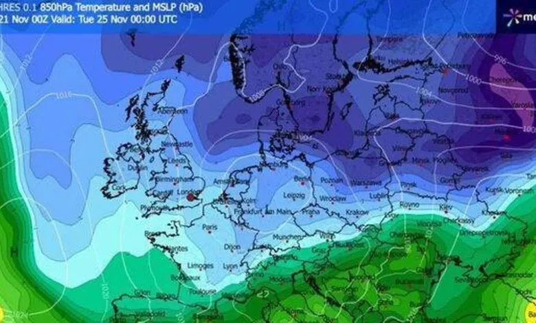
A huge band of freezing air is set to hover over northern Europe (Image: Netweather)
Manchester, Birmingham, Nottingham, and Derby will experience slightly warmer conditions, with temperatures between 1C and 2C. London, however, will manage to stay in positive figures, with lows of 1C.
In contrast, coastal and southern areas in England will enjoy milder weather, with temperatures ranging from 7C to 12C.
A WXCharts weather map for November 25 shows a massive dark blue mass sweeping in from the North, indicating temperatures as low as -8C coming in from the Arctic. This 850 hPa weather map reveals atmospheric conditions about one mile above sea level, useful for identifying large-scale air masses.
The UK is currently being blasted a cold, Arctic air mass(Image: Getty)
It comes after cold weather brought snow, ice and temperatures as low as minus 12C last week. Parts of the country will suffer heavy rain as the cold snap ends but more unsettled weather will set in over the coming days, the Met Office said.
The Met Office’s Becky Mitchell said: “This weekend we’ve got bands of rain crossing the country. So we’ll start to see snow melt away where we’ve got it. It’s generally looking a bit more unsettled.”
For the latest breaking news and stories from across the globe from the Daily Star, sign up for our newsletter by clicking here.