Temperatures have been running colder than normal for this time of year in Maryland. A cold and occasionally unsettled weather pattern continues through the end of the week. Our next chance of wintry weather arrives later in the workweek.
The WJZ First Alert Weather Team has upgraded Friday to a WJZ First Alert Weather Day for snow Friday late morning through early Friday evening. Due to the cold temperatures, any untreated surfaces could be slippery.
Cold and quiet in Maryland through Thursday
Thursday will start off quiet and cold with early morning temperatures in the upper 20s and lower 30s in the immediate metro; colder farther away from the city. Frost could be thick in a few spots early Thursday morning. As Thursday plays out, we’ll see an increase in clouds and gusty winds. Temperatures briefly warm into the lower 40s, as clouds and winds increase. Another batch of cold air is set to blow into Maryland through the second-half of the day. Thursday evening will be quite cold, with temperatures dropping below freezing right after sunset
Temperatures plummet into the upper teens and lower 20s Thursday night. A light breeze will make it feel even colder.
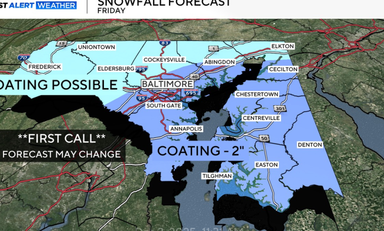
Alert Day Friday for light snow, slippery spots in Baltimore metro
An storm system to our south and west will approach central and eastern Maryland on Friday.
On the northern side of this storm system, a large area of snow showers and steady light snow will push into parts of our area from the south and west. While the snow start time is not in stone yet, it appears that snow showers or light snow could begin as early as Friday morning… continuing through Friday afternoon, before tapering off sometime Friday evening.
Friday’s high temperatures will barely reach the freezing mark. Any snow that does fall will stick, especially on untreated surfaces. Treated surfaces should remain only wet. Be extra careful on sidewalks, bridges and overpasses.
Right now areas along and east of I-95, including Baltimore City, should see anywhere between a coating and 2 inches of snow. The chance of two inches of snow is greatest south of Route 50. Areas to the north & west on I-95 will be farther away from the steadier snow. But, snow cannot be ruled out on the north side of the metro.
Untreated surfaces will be slippery through Saturday morning until temperatures rise above freezing. This forecast may be tweaked over the next day so check back for updates.
WJZ
Staying Chilly across Maryland this weekend
Our upcoming weekend looks dry and chilly with seasonably cold temperatures Saturday will feature clouds and limited sunshine, with highs in the upper 30s and lower 40s. Overnight temperatures will drop back below freezing each night.
The Ravens game on Sunday looks mostly dry with a mix of sun and clouds. The forecast could trend a bit more unsettled late Sunday into early next week.
Another shot of Arctic cold early next week in Maryland
Another round of unseasonably cold air will sweep into Maryland early next week.
Monday looks mostly dry and cold, with high temperatures in the mid-30s. Models have occasionally shown a fast-moving band of rain or snow moving through the mid-Atlantic either Monday, or Tuesday. Some rain and snow remains possible early next week, locally. We’ll be fine-tuning that portion of the forecast over the next few days.