A Winter Weather Advisory has been issued for Lapeer, Sanilac, and St. Clair counties from 10:00 p.m.tonight until 4:00 p.m. Wednesday. These are the areas that will get the most snow, totals of 4″-6″, and the least rain tonight and tomorrow.
After 3 a.m. temperatures will warm enough where snow will change to rain starting south and pushing north through 6 a.m.
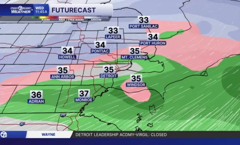
There is also the possibility for a bit for sleet and freezing rain during this transition in areas north of Metro Detroit. From 6 a.m. to 11 a.m. rain showers will continue in areas south of I-69, with snow continuing north. A cold front sweep through after 11 a.m. switching everyone back to snow. Snow showers end in the afternoon. Snowfall totals will vary quite a bit through the morning and across the area.
Here’s a look at forecasted snowfall totals in the full forecast below:
Metro Detroit Weather: Tracking snow, rain & sleet in metro Detroit
Much colder air returns Thursday with a few flurries from Lake Michigan lake effect. A few more snow chances continue into this weekend. Temperatures continue to be well below average with highs in the mid to upper 20s to end the workweek, and in the teens and low 20s this weekend.
Tonight: Mostly snow until around 3 AM, then a transition to rain will work south to north. Lows in the low 30s with temps rising to the mid 30s by the morning commute in Metro Detroit. Wind: SSW 10-25 mph.
Wednesday: From rain to snow in the morning and then some light snow into early afternoon. Highs in the mid to upper 30s in the morning and then dropping below freezing by evening. Wind: WNW 10-25 mph.
Thursday: Much colder with lows in the teens and highs in the 20s. Wind chills will be in the teens most of the day.
Connect with 7 First Alert Meteorologists on Facebook and X:
Facebook: Dave Rexroth , Hally Vogel, Marisa Woloszyn, Mike Taylor
X: Dave Rexroth , Hally Vogel, Marisa Woloszyn, Mike Taylor
- Humidity: 94%
- Dew point: 33°
- Pressure: 29.28 in
- Wind speed: 9 mph
- Wind direction: SSW
- Visibility: 1.0 mi
- Sunrise: 07:51 AM
- Sunset: 05:00 PM