December 10 Blizzard Warning For The Mountains While Windy Rain For Most Colder Winds And Weekend Snow Still On
Wednesday Morning December 10
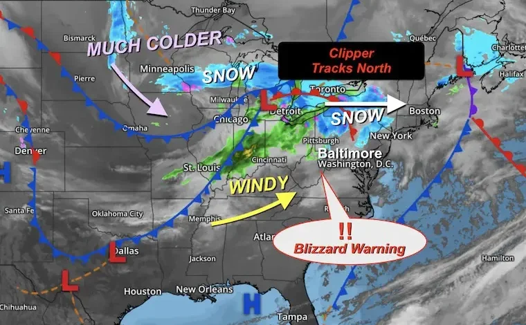
This is going to be a wild day with building winds and brief warming, which will bring most of us rain early afternoon. The mountains will experience colder winds up to 50 mph along with Heavy Snow. The result has prompted a Blizzard Warning. Forecast maps highlight the details below.
Why is this happening? A fast-moving clipper storm is tracking north of us. This will surge warmer winds into the region today and keep the snow north… then eventually west.
This morning, there is some light precipitation in Southern Pennsylvania that might not all reach the ground. If it is, there may be flurries or light freezing drizzle near Lancaster.
A squall line may develop with the cold front when it arrives this afternoon. This will push winds over 40 mph with rain in metro areas…
The Mountains in the Advisories will start with rain, then transition to snow during the day.
SNOW ALERTS
Blizzard Warning is in effect for western Garrett County to West Virginia.
Winds to 50 mph with WHITE OUTS and snow at times falling 1” per hour.
LIVE CAM:
Wisp Ski Resort at Deep Creek Lake in McHenry, Maryland
This webcam is positioned at The Greene Turtle Deep Creek Lake and shows Wisp Resort, including a zoomed-in view of Squirrel Cage, The Face, the terrain park, Boulder, the mountain coaster, the tubing park and a shot of McHenry Cove at Deep Creek Lake!
Radar Simulation 7 AM to Midnight
2 PM Snapshot
6 PM Snapshot
Midnight Snapshot
Snow Forecast
McHenry and Wisp Ski Resort can expect one to 4 inches. There will be heavier snow on higher terrain, where parts of West Virginia can get between 6 to 12 inches of fresh snow.
Morning Temperatures
Morning Surface Weather
A fast-moving clipper storm is tracking north of us. This will surge warmer winds into the region today and keep the snow north… then eventually west.
A squall line may develop with the cold front when it arrives this afternoon. This will push winds over 40 mph with rain in metro areas…
The Mountains in the Advisories will start with rain, then transition to snow during the day.
Wind Forecast 7 AM to Midnight
Afternoon Wind Forecast
Afternoon Temperatures
CLIMATE DATA: Baltimore
Yesterday: Low 14F; High 32F
Precipitation: 0.00”
Snow = 0
Season Snow Total: 1.0″
Top Wind Gust: 26 mph
TODAY December 10
Sunrise at 7:15 AM
Sunset at 4:44 PM
Normal Low in Baltimore: 31ºF
Record 1ºF in 1876
Normal High in Baltimore: 49ºF
Record 72ºF 1966
Rainfall Deficit at BWI
- Ending 2024 = -8.00”
- Since Jan 1 = 7.00”
- We are STILL DOWN -7.00” INCLUDING LAST YEAR
Subscribe for eMail Alerts
Weather posts straight to your inbox
Sign up and be the first to know!
If It Snows On Christmas: Jarrettsville Furniture Special
FAITH IN THE FLAKES STORE
NOW OPEN FOR THE SEASON
click here
THURSDAY
This will be a windy and colder day, with snow lingering in the mountains in the morning.
Morning Temperatures
Morning Wind Chills
Wind Forecast 7 AM to 7 PM
Afternoon Temperatures
Afternoon Wind Chill
Looking Ahead:
Weekend Forecast (ECMWF): 7 AM Friday to 7 AM Sunday
Two clippers are still expected to cross through the Mid-Atlantic.
The track is looking to move across Maryland with a light snow that may affect Friday overnight to Saturday Morning. Then another on Sunday morning. The second will be the stronger of the two.
Friday Night/Early Saturday
Light Snow overnight into the morning may be enough to coat the ground or bring a light accumulation.
Sunday Morning
This will be the stronger of the two clippers and may affect roads at daybreak.
SNOW ODDS
The CHANCE for 1 inch of snow or more by Sunday.
At this time, Baltimore has a 50% chance for snow to add up 1” or more. It might not sound like much, but that could affect travel.
7 Day Forecast
Chance For Light Snow
Late Friday Night And Sunday Morning
Subscribe for eMail Alerts
Weather posts straight to your inbox
Sign up and be the first to know!
Snow Report December 5 to 6 and Grade My Forecast
In case you missed it. The brief summary of the final snow totals from the last event.
My Winter Outlook For Above-Average Snow
Click here for the full report
La Niña Advisory
This was issued October 9, as expected: A weak and short-lived event to start winter may play a different role this winter.
In Case You Missed It
Woolly Bear Caterpillar Winter Folklore
These are NOT all the same caterpillar!
Winter Outlook From 2 Farmers’ Almanacs
STEM Assemblies/In School Fields Trips Are Back
Click to see more and ‘Book’ a visit to your school
THANK YOU:
Baltimore Sun Magazine Readers’ Choice Best Of Baltimore
Maryland Trek 12 Day 7 Completed Sat August 9
UPDATED: We raised OVER $170,000 for Just In Power Kids – AND Still Collecting More
The annual event: Hiking and biking 329 miles in 7 days between The Summit of Wisp to Ocean City.
Each day, we honor a kid and their family’s cancer journey.
Fundraising is for Just In Power Kids: Funding Free Holistic Programs. I never have and never will take a penny. It is all for our nonprofit to operate.
Click here or the image to donate:
RESTATING MY MESSAGE ABOUT DYSLEXIA
I am aware there are some spelling and grammar typos and occasional other glitches. I take responsibility for my mistakes and even the computer glitches I may miss. I have made a few public statements over the years, but if you are new here, you may have missed it: I have dyslexia and found out during my second year at Cornell University. It didn’t stop me from getting my meteorology degree and being the first to get the AMS CBM in the Baltimore/Washington region. One of my professors told me that I had made it that far without knowing and to not let it be a crutch going forward. That was Mark Wysocki, and he was absolutely correct! I do miss my mistakes in my own proofreading. The autocorrect spell check on my computer sometimes does an injustice to make it worse. I can also make mistakes in forecasting. No one is perfect at predicting the future. All of the maps and information are accurate. The ‘wordy’ stuff can get sticky. There has been no editor who can check my work while writing and to have it ready to send out in a newsworthy timeline. Barbara Werner is a member of the web team that helps me maintain this site. She has taken it upon herself to edit typos when she is available. That could be AFTER you read this. I accept this and perhaps proves what you read is really from me… It’s part of my charm. #FITF