3:45 P.M. UPDATE: A Winter Storm Warning has now been issued for Gloucester, Camden and Burlington counties in New Jersey, as well as Delaware County and Philadelphia.
PHILADELPHIA – A winter storm will bring snow to the Philadelphia region tonight, followed by a blast of dangerous cold lasting through early next week, according to the National Weather Service in Mount Holly.
What we know:
Snow begins this evening and continues into early Sunday morning. Some areas near and southeast of I-95 may start with light rain before the colder air takes over. Once temperatures fall below freezing, snow will begin to stick to roads and sidewalks.
How much is it going to snow?
Expected snowfall amounts from Saturday night into Sunday morning:
- Philadelphia: 4–6 inches
- Trenton: 4–6 inches
- Wilmington: 4–6 inches
- South Jersey (including Camden, Gloucester, Burlington counties): From 1–2 inches near Cape May, to 2–3 inches near Atlantic City and more further north
- Shore communities (Atlantic City, Toms River): 3–4 inches
- Lehigh Valley & Reading: 3–4 inches
- Northern NJ (Sussex, Morris): 3–4 inches
The NWS predicts decent chances for even larger snow totals throughout the area. Officials said Philadelphia has a 75% chance of seeing 4 inches of snow or more through Sunday morning, and a 38% chance to see 6 or more inches.
A narrow zone of 5+ inches is possible just southeast of I-95, where snowfall rates could briefly reach 1 inch per hour.
Travel impacts
Roads are expected to become snow-covered and slippery, especially after midnight. Visibility may drop quickly if heavier snow bands set up during the late evening and early morning hours.
Wind gusts picking up Sunday into Monday may lead to blowing snow, reducing visibility even after the snow ends.
Warminster Township in Bucks County issued a state of emergency starting at 6 p.m. on Saturday, and continuing noon on Sunday, to help emergency management teams respond to the storm.
When is the snow going to start?
Based on the precipitation onset map:
- Philadelphia: Snow starts at roughly 11 p.m.
- South Jersey: Between 11 p.m Saturday and 5 a.m. Sunday
- Lehigh Valley / Poconos: 8–9 p.m. Saturday
- Delaware: 11 p.m.–7 a.m. Sunday
- Most of the snow will fall between midnight and 9 a.m. Sunday.
Dangerous cold to follow
Once the storm pulls away, Arctic air will move in.
NWS Mount Holly projects wind chills near 0°F across much of the region late Sunday night into Monday morning, with below-zero wind chills in the Poconos.
Minimum wind chills Sunday night into Monday:
- Philadelphia: 8°
- Trenton: 3°
- Wilmington: 8°
- Atlantic City: 4°
- Vineland: 0°
- Mount Pocono: –7°
Monday’s air temperatures will remain below freezing for most of the region.
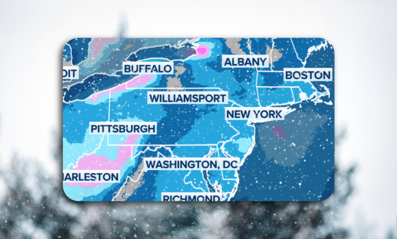
Snow potential for Midwest, Northeast. (FOX Weather)
Marine hazards
A Gale Warning is in effect Sunday afternoon into Monday for Delaware Bay and NJ/DE coastal waters, with wind gusts up to 35–40 knots and possible freezing spray.
What’s next:
Snow should taper late Sunday morning, but the cold that follows may linger through Tuesday. Residents are urged to prepare for freezing conditions, protect pets and pipes, and check for updated advisories.
The Source: This story is based on the National Weather Service Mount Holly briefing package and reports from FOX Weather.
WeatherPhiladelphiaNew JerseyDelaware


![Eastern Washington vs. North Texas prediction: North Texas favored to win men's college basketball matchup [11/25/2025]](https://cdn1.emegypt.net/wp-content/uploads/2025/11/Eastern-Washington-vs-North-Texas-prediction-North-Texas-favored-to-390x220.webp)