Temperatures could reach freezing in some locations
Maxine Denton, Matt lloyd, Emily Wright, Liam Doyle and Matt LLoyd
16:21, 14 Dec 2025
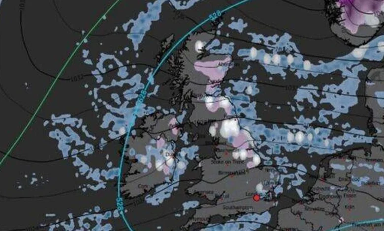
Weather maps show where could see a White Christmas(Image: WXCharts)
Some areas of Britain look set for a white Christmas this year, with the latest weather charts indicating snow could push much further south than anticipated – potentially even reaching London on Christmas Day itself.
New data from WXCharts, showing conditions at noon on December 25, reveals widespread wintry showers covering the UK, with snowfall predicted from Scotland right down to the Home Counties.
Whilst northern areas are accustomed to festive flurries, the current modelling suggests considerably colder air penetrating deeper into England, boosting the chances of a seasonal dusting in the capital.
The charts show a combination of light to moderate snowfall across central and northern parts of the country, with heavier deposits anticipated over Scotland’s higher ground.
Crucially, the ‘528 line’ on the forecast – a key meteorological marker employed to assess snow likelihood – extends well into southern England, reports Birmingham Live.
This reinforces the prediction for borderline yet possible snowfall across the southeast, especially during shower periods.
The 528 line acts as an essential reference point for weather experts when forecasting wintry conditions – regions positioned north of this threshold are prone to receive precipitation as snow, whereas those to the south are more likely to encounter rainfall.
A distinctive ‘Minimum Temperature’ WXChart map for Christmas Day reveals chilly air covering northern and central parts of the UK, with temperatures plummeting near freezing across Scotland, northern England and portions of Northern Ireland, according to the Mirror.
The chart displays areas of 0-2C extending from Aberdeen and Dundee southwards to Newcastle and the Pennines, whilst marginally milder but still brisk conditions of 4-7C are predicted further south.
Should these forecasts prove accurate, much of Britain could wake to snow flurries or at the very least the prospect of snow showers, with Scotland, northern England and Ireland confronting the highest probability.
For London and the Midlands, conditions may depend on shower timing and how dramatically temperatures plummet on Christmas morning.
While the earlier chart suggests widespread snow showers, a snow-depth prediction provides a more detailed perspective of where accumulation could take place.
According to this mapping, settled snow on Christmas Day seems largely confined to the Scottish Highlands, with depths of 2cm to 6cm anticipated around Inverness, Aviemore and higher ground west of Dundee.
The Met Office consistently stresses that predicting snowfall remains challenging, particularly well ahead of time, as minor alterations in temperature, wind direction or the boundary between rain and snow can drastically influence where wintry conditions develop.
Its own long-range forecast spanning December 16 to December 25 states: “Unsettled at first with spells of rain affecting the UK at times.
“Some heavy rain is possible anywhere, but it is likely to be heaviest and most persistent in the west and northwest, with sheltered parts of the east and southeast typically drier.
“Any snow will probably be confined to high ground in the north.
“Strong winds are possible at times with a risk of gales, especially along coasts and over higher ground.
“Temperatures are likely to be above normal overall.
“Later in the period, conditions may start to become a little more settled, with rainfall amounts decreasing and drier weather becoming more prevalent, especially in the south.
“This may mean an increasing amount of overnight fog and frost.”