First of its kind “Particularly Dangerous Situation” issued in Colorado for high fire danger
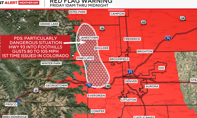
For the first time in Colorado, the National Weather Service has issued a ‘Particularly Dangerous Situation’ for high fire danger in the Foothills on Friday afternoon. The rarity of the PDS emphasizes the conditions that will be present across Colorado on Friday.
CBS
For the Highway 93 corridor, West into the Foothills, winds could gust 85–105 miles per hour. Those powerful winds, coupled with a very dry airmass, critically dry fuels, and record warmth, all could lead to rapidly spreading, uncontrollable wildfires. This kind of warning is stronger than the standard Red Flag Warnings issued across other parts of Colorado.
Friday’s wind event will also likely last into the overnight hours, causing more power outages and extending outages for those currently without power.
The strongest winds for the Foothills are anticipated to last through the afternoon, gradually relaxing overnight.
For the Denver Metro area, expect wind gusts up to 40 mph through this afternoon.
Winds will last a little longer and be a little stronger for parts of Northern Colorado, gusting up to 60 mph through this evening.
CBS
The wind and record warmth coupling together are what make Friday concerning for fire danger.
By noon on Friday, the previous record high temperature was broken at the airport (68 F, previous record 67 F) as temperatures continue to warm into the upper 60s, low 70s.
CBS
Late Friday night into Saturday, a storm system moving in from the Pacific Northwest will bring some snow to the high country.
Winter Weather Advisories are in place for Rabbit Ears Pass, Rocky Mountain National Park, Medicine Bow Range, Summit County, Mosquito Range, and Indian Peaks through midnight Saturday.
Most places will see 1-4 inches, with pass levels potentially receiving as much as 12″.
Winds in those areas could also gust up to 60 mph, causing blowing snow and low visibility.